Tag: German World War II Captured Maps
Lines of Latitude: German Army Map of Spain 1:50,000 (1940-1944)
Beginning in 1936, a newly-formed German military mapping agency produced a large number of topographic map series covering all parts of Europe at various scales, as well as much of northern Africa and the Middle East.
This organization started out as a back room department of the German Army General Staff, focused on military contingency mapping. But, given the murderous goals of the Nazi regime, it quickly morphed into something else, a military mapping agency which provided planning tools for the Nazi leadership to wage a war of conquest, marked by atrocities and unspeakable crimes.
Berkeley’s Earth Sciences and Map Library owns 20,000 German topographic sheet maps produced by the German Army General Staff’s mapping agency, the Directorate for War Maps and Surveying [= Abteilung für Kriegskarten- und Vermessungswesen]. The Berkeley Library obtained this historically significant collection by participating in the World War II Captured Maps depository program of the U.S. Army Map Service.
A presentation by Wolfgang Scharfe, a geography professor at the Free University of Berlin, at the International Cartographic Conference in Durban in 2003, sheds light on the history of these military map series published by the Directorate for War Maps and Surveying. Scharfe looked at one particular topographic map series covering Spain, published in 2 editions between 1940 and 1944, Spanien 1:50 000.
German military cartographers mapped Spain at different scales. The Nazis saw Spanish dictator Francisco Franco’s fascist regime as an ally, but Franco wisely remained neutral during World War II. Initially, the German military mapping of Spain can be seen as part of an effort to bring the Franco dictatorship into the Second World War as a German ally. One goal was the capture of the important British base at Gibraltar, at the entrance to the Mediterranean Sea.
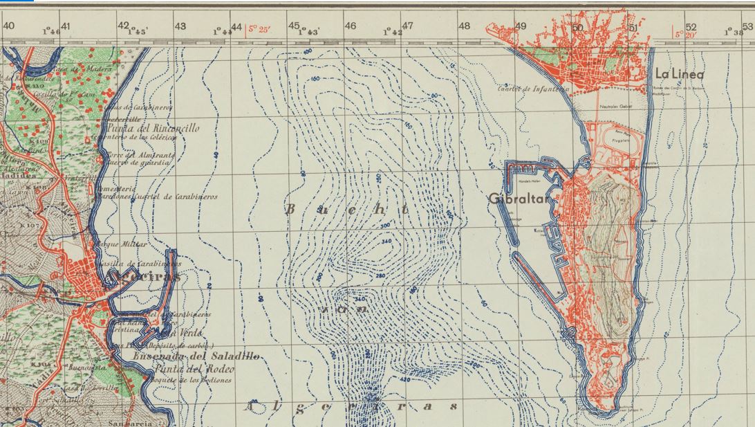
The Bay of Gibraltar, also known as Gibraltar Bay and Bay of Algeciras, identified on the German sheet La Linea-Gibraltar as Bucht von Algeciras. It is located at the southern end of the Iberian Peninsula, near where the Atlantic Ocean and the Mediterranean Sea meet. The sheet is overprinted with the Spanish Lambert Grid, obtained by German military cartographers in an undercover intelligence operation.
The Berkeley Library set of the German Army Map of Spain 1:50,000 consists of 901 sheet maps, accompanied by 3 index maps. It includes two editions of many topographic sheets which cover specific areas of Spain. First Special edition [= Sonderausgabe] sheets were issued between 1940 and 1944, while the second Sonderausgabe sheets were chiefly issued in 1941.
The source map data for the German military maps came from a Spanish map series, the Mapa topográfico de España en escala de 1:50,000 issued by the Direccion general del Instituto Geográfico Catastral y de Estadı́stica.
Scharfe explains that map specialists of the Army Planning Chamber [= Heeresplankammer], the Berlin-based production platform of the Directorate for War Maps and Surveying, copied the Spanish map data. The first edition of this map series (895 published sheets) only contained the Spanish map data. The maps show drainage, roads and trails, railways, vegetation, and other physical and cultural features.
Sheets of the second edition (612 sheets), however, were overprinted with the Spanish Lambert Grid, a geodetic grid which would allow German troops to use the maps to accurately rain down middle and long-range artillery fire on precise locations.
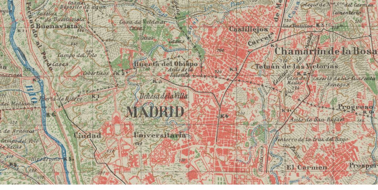
Detail from the Madrid sheet of the German military topographic map series Spanien 1:50 000, published by the Directorate for War Maps and Surveying, a military mapping agency administratively subordinated to the German Army General Staff.
The German military cartographers were able to acquire this secret Spanish military grid data for their own sheets, before that data even appeared on Spanish military maps. This was the result of a German undercover intelligence operation. German agents were able to draw on contacts established when the Nazis aided the fascist Franco dictatorship during the Spanish Civil War (1936-1939) by sending German troops to Spain, the so-called Legion Condor.
But the story does not end there: Scharfe relates that in 1943, irregular Spanish soldiers raided a German Army depot in Nazi-occupied southern France. They removed sheets of the German Army Map of Spain 1:50,000 with the secret Spanish military grid data. Spanish officials started an official inquiry which undoubtedly further undermined trust between the fascist Franco regime and the Nazis. Spanish diplomatic demands for explanations registered in Berlin proved unsuccessful.
Lines of Latitude: The Long Shadow of Vienna’s Militärgeographisches Institut (1818-1918)
Beginning in the 1840s, the Kaiserliches und Königliches Militärgeographisches Institut [= Imperial and Royal Military Geographical Institute] of the Austro-Hungarian monarchy published many thousands of quality topographic sheets covering much of Central and Eastern Europe, areas where the Habsburg empire had strategic interests. These sheets did not just survey the territory of the Austro-Hungarian monarchy, they also provided solid coverage for neighboring parts of the Ottoman and Tsarist empires.
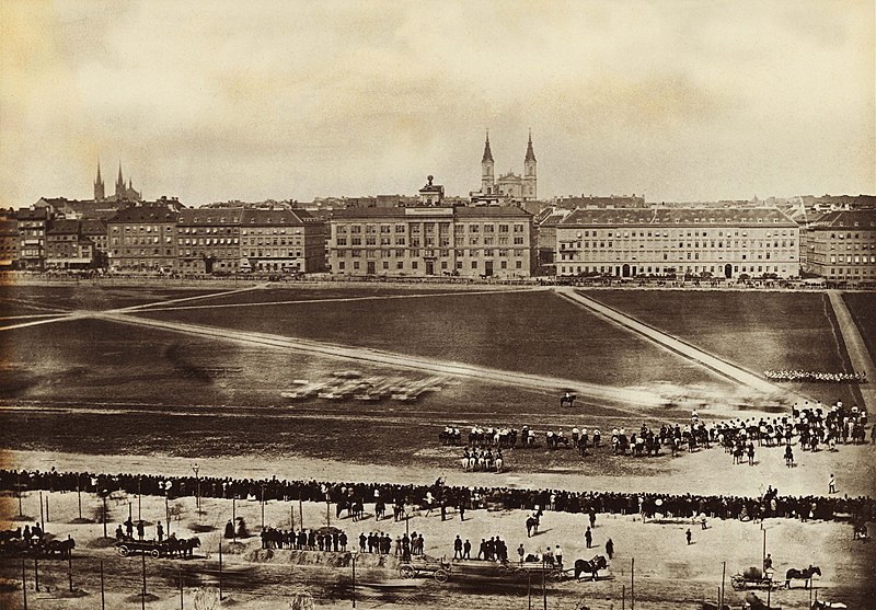
Building of the Militärgeographisches Institut, parade grounds, Josefstädter Glacis, Vienna, Austria, 1860.
The quality of the Habsburg mapping operation was greatly aided by its adaption of the Bessel ellipsoid which fits especially well to the geoid curvature of Europe. The ellipsoid data published by Friedrich Wilhelm Bessel, a professor of astronomy at the University of Königsberg, in 1841 were then the best and most modern data mapping the figure of the Earth. Because of the recognized high quality of their work, Austrian triangulation parties were admitted into neighboring countries. That work was reflected on Austrian topographic maps covering these areas.
 Globe on the roof of the building which housed the Militärgeographisches Institut until 1918.
The Militärgeographisches Institut issued a number of iconic map series, including the Spezialkarte der Österreichisch-Ungarischen Monarchie im Masse 1:75 000. Eventually, 752 quadrangles of this legendary map series were produced, starting in 1873. After the collapse of the Austro-Hungarian Empire at the end of World War I Austria’s Kartographisches Institut, and Hungarian, Czechoslovak, and German mapping agencies continued to issue updated sheets.
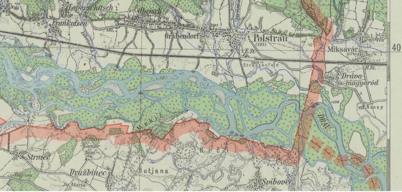
Spezialkarte 1:75 000, sheet # 5456 Pettau shows parts of the Drava river valley, with the borders of Nazi Germany, Hungary, and Croatia, last updated 1943 by a regional survey office of Germany’s civilian mapping agency Reichsamt für Landesaufnahme.
In March 1938 Nazi Germany annexed Austria. This was an important stepping stone in Adolf Hitler’s plans for waging a war of aggression. In Vienna the Nazi regime gained access to important resources and capabilities. German civilian and military mapping agencies moved quickly to incorporate Austrian government institutions active in the fields of surveying and cartography. The new Vienna office of Germany’s civilian Reichsamt für Landesaufnahme absorbed Austria’s well-regarded Kartographisches Institut. The German military incorporated the Austrian Army’s survey office.
Rather than reinvent the wheel German World War II military planners pragmatically worked within an established Austrian framework when they mapped parts of central and southeastern Europe. They continued to issue a number of Austrian map series with a long publishing history which reached far back into the 19th century. The Militärgeographisches Institut, defunct since 1918, cast a very long shadow.
A German military map series with more limited geographical coverage, the Spezialkarte von Österreich, von Ungarn, und der Tschechoslowakei 1:75 000, was published between 1935 and 1944. It was based on 1:75,000 source maps issued 1924-1939 by various Central European mapping agencies. During World War II, Spezialkarte sheets also provided the source map data for various other German military map series which covered large parts of central and southeastern Europe at a scale of 1:50,000.
The UC Berkeley Library acquired 420 sheets of this German military map series through the depository program of the U.S. Army Map Service (AMS) in the 1950s. U.S. Army military intelligence had collected these maps in Germany between October 1944 and September 1945, in the final months of World War II. Today these maps are part of UC Berkeley’s German World War II Captured Maps collection.
Lines of Latitude: German military map series Norwegen/Finnland 1:50 000 (1943-1944)
In 1961 University of California map librarian Sheila T. Dowd took stock: In an article published in the Special Library Association’s Geography and Map Division Bulletin she analyzed the growth of Berkeley’s map collection. Since 1917 its size had quadrupled. Growth came especially in the years following World War II.
Dowd found that the primary driver of that increase in size was Berkeley’s participation in the depository programs of the U.S. Army Map Service (AMS). And she highlighted the impact of the AMS World War II Captured Maps depository program. Ultimately 22,000 German and Japanese World War II maps found their way into Berkeley’s map collection. Most were topographic quadrangles published as part of military map series issued by Axis military mapping agencies.
Sometimes local German military bodies played important roles: Armee-Kartenstelle (mot.) 464 [= Army Maps Post (motorized) 464], served as mapping unit of the 20th German Mountain Army in Lapland during World War II. This area, northernmost Norway and Finland and adjacent areas of the Soviet Union, consisted of forbidding terrain, largely permafrost tundra.
A.K.St. (mot.) 464 produced the German military map series Norwegen/Finnland 1:50 000 to support German mountain troops fighting on the Eastern Front against the Soviet Red Army. One important challenge for the German military mapmakers was the need to document Arctic tundra freeze-thaw cycles. Winters north of the Arctic Circle are long and summers are short. The active layer of permafrost, the topmost layer of soil, thaws in the summer and freezes in the winter. This, of course, greatly affects military operations.
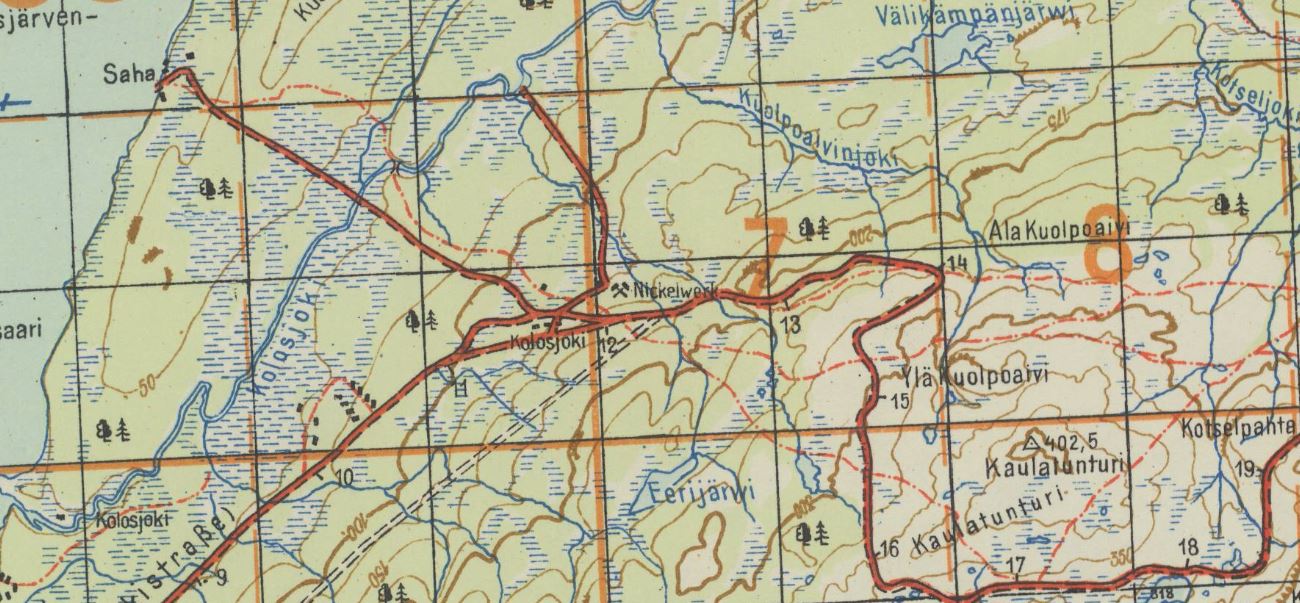 Kolosjoki quadrangle with 2 German military grids, Deutsches Heeresgitter [= German Army Grid], and Heeresmeldenetz [= Army Messaging Web] overprinted in orange. Shows “Nickelwerk,” a mine where nickel, a rare metal used as steel hardener, was extracted. The nickel deposits of northern Finland were important to the German war effort in World War II. This sheet was produced in October 1943.
In 1942, Armee-Kartenstelle (mot.) 464 had a staff of 53. The unit compiled maps utilizing Finnish, Norwegian and Soviet source map data, aerial photographs of the Luftwaffe, and by performing field checks. It was motorized and equipped with trucks and half a trailer with the mapping and map printing equipment installed. Maps were chiefly printed in color.
A.K.St. (mot.) 464 established a base at Lager Neuer Kolonnenhof, a military camp of about 60-70 barracks, in Rovaniemi, Finland, in January 1942. The unit occupied a headquarters building, two garages for trucks, a workshop, a gas station and other barracks. As the frontlines approached in October 1944 German troops burned down the camp, and also much of the city of Rovaniemi, a war crime, and retreated to northernmost Norway.