Tag: Norway
Lines of Latitude: German military map series Norwegen/Finnland 1:50 000 (1943-1944)
In 1961 University of California map librarian Sheila T. Dowd took stock: In an article published in the Special Library Association’s Geography and Map Division Bulletin she analyzed the growth of Berkeley’s map collection. Since 1917 its size had quadrupled. Growth came especially in the years following World War II.
Dowd found that the primary driver of that increase in size was Berkeley’s participation in the depository programs of the U.S. Army Map Service (AMS). And she highlighted the impact of the AMS World War II Captured Maps depository program. Ultimately 22,000 German and Japanese World War II maps found their way into Berkeley’s map collection. Most were topographic quadrangles published as part of military map series issued by Axis military mapping agencies.
Sometimes local German military bodies played important roles: Armee-Kartenstelle (mot.) 464 [= Army Maps Post (motorized) 464], served as mapping unit of the 20th German Mountain Army in Lapland during World War II. This area, northernmost Norway and Finland and adjacent areas of the Soviet Union, consisted of forbidding terrain, largely permafrost tundra.
A.K.St. (mot.) 464 produced the German military map series Norwegen/Finnland 1:50 000 to support German mountain troops fighting on the Eastern Front against the Soviet Red Army. One important challenge for the German military mapmakers was the need to document Arctic tundra freeze-thaw cycles. Winters north of the Arctic Circle are long and summers are short. The active layer of permafrost, the topmost layer of soil, thaws in the summer and freezes in the winter. This, of course, greatly affects military operations.
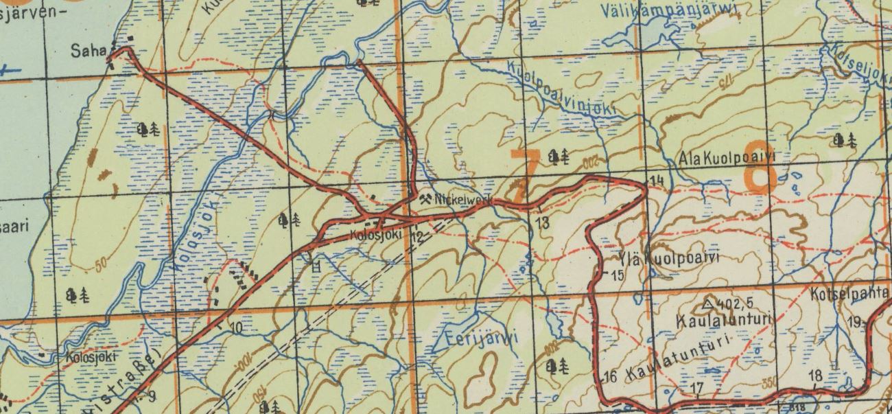 Kolosjoki quadrangle with 2 German military grids, Deutsches Heeresgitter [= German Army Grid], and Heeresmeldenetz [= Army Messaging Web] overprinted in orange. Shows “Nickelwerk,” a mine where nickel, a rare metal used as steel hardener, was extracted. The nickel deposits of northern Finland were important to the German war effort in World War II. This sheet was produced in October 1943.
In 1942, Armee-Kartenstelle (mot.) 464 had a staff of 53. The unit compiled maps utilizing Finnish, Norwegian and Soviet source map data, aerial photographs of the Luftwaffe, and by performing field checks. It was motorized and equipped with trucks and half a trailer with the mapping and map printing equipment installed. Maps were chiefly printed in color.
A.K.St. (mot.) 464 established a base at Lager Neuer Kolonnenhof, a military camp of about 60-70 barracks, in Rovaniemi, Finland, in January 1942. The unit occupied a headquarters building, two garages for trucks, a workshop, a gas station and other barracks. As the frontlines approached in October 1944 German troops burned down the camp, and also much of the city of Rovaniemi, a war crime, and retreated to northernmost Norway.