Tag: José de Cãnizares
Lines of Latitude: Plano del puerto de Sn. Francisco (1776)
The most wonderful nautical chart of San Francisco Bay is the very first one that was ever made, in 1776.
A manuscript map, pen-and-ink and watercolor. Attributed to José de Cañizares, a Spanish naval officer. Cañizares was an ensign on Juan Manuel de Ayala’s ship, the packet boat San Carlos, i.e. a transport.
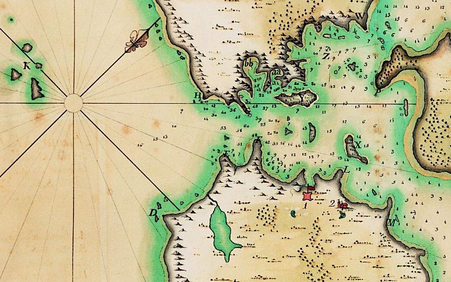
Plano del puerto de Sn. Francisco : situado por los 37. grs. 53 mins. de latitud septentrional, y por 17. grs. 10. mins. de longitud occidental del puerto de Sn. Blas: registrado por el paquebot de S.M. el Sn. Carlos al mando de Dn. Juan Manuel de Ayala, Teniente de Fragata de la Real (Real) Armada.
In 1768, the Spanish government drew up plans to built a naval base at San Blas, on the Pacific Coast of what is now Mexico, a bit north of Puerto Vallarta.
Three ships were sent north in 1775, for a Spanish expedition to explore the Pacific Northwest.
One of the ships was the transport San Carlos commanded by Juan Manuel de Ayala, the only Spanish ship to enter San Francisco Bay in 1775.
High resolution PDF:
https://www.lib.berkeley.edu/EART/maps/g4362s22_1776_c4.jpg
Image in the University of California’s digital collection:
https://digicoll.lib.berkeley.edu/record/58550
Various other nautical charts document the work of José de Cañizares in San Francisco Bay in 1775, including this one:
Plano del Puerto de San Francisco, registrado por el Paquebot de S.M. San Carlos, al mando del theniente de Fragata de la Real Armada Don Juan Manuel de Ayala, en esta año de 1775.
https://digicoll.lib.berkeley.edu/record/58549